We have very little graphic evidence of how the ancients viewed the geography of their world. The only "map" which has survived in its original form from the Roman world is the Peutinger Map (or Table as some prefer to call it) with dimensions of 22 feet long and only 1 foot wide (fragments of a giant wall map of Rome, known as the Marble Plan, created in the early 2nd century AD, have also have been found) . Below is the far left (western) portion of the map which ends in a damaged and lost section.

The first documented reference to the Map is in the will of Conrad Celtes, dated January 24, 1508, in which it is referred to as the Itinerarium Antonini Pii (after the Roman Emperor Antoninus Pius, 138-163AD). Celtes bequeathed it to the German collector and scholar Konrad Peutinger. The original is now in the possession of Austria's National Library in Vienna where it has resided since 1737.
How Celtes located the map remains uncertain. The best current analysis indicates his copy was made by a German monk in the 13th century and based upon the Roman original or an earlier copy of the original.
The map contains over 4000 place names including over 500 cities and schematically shows the road routes (the straight red lines as shown below) between cities which is why it is often described as an Itinerary. It also portrays major mountain ranges and rivers. It is not orientated like a map today. Because of its narrow width and long length the actual locations of parts of the Roman world are distorted. In the European section, northern and eastern Europe are shown on the top, Italy in the middle and North Africa on the bottom. It can take awhile for the casual observer to figure out what they are looking at when they view the map.
When the original was made is another subject of controversy. The most comprehensive recent publication on Peutinger is Rome's World: The Peutinger Map Reconsidered by Richard JA Talbert (2010) and its accompanying website.
 (Depiction of Rome on Map)
Talbert believes that the original was made in the early 4th century for display purposes, not for actual use while traveling, and shown in the throne room or other prestigious public places used by one of the Tetrarchs - Diocletian, Maximium, Galerius and Constantius Chlorus.
The section below shows in detail the schematic layout of the map. In this segment, the top section is the eastern side of the Adriatic Sea (modern day Croatia and Albania). Below it is the "boot" of Italy. Next is a very elongated Sicily and then North Africa.

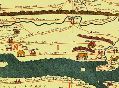
Below is the section showing the Bay of Naples with Neapoli (Naples), Oplontis and Pompei. It even shows Sorrento and the Amalfi Peninsula.
Below you can look at the entire map courtesy of the Tabula Peutingeriana entry in Wikipedia. Just keep scrolling across (the section in white on the left end is a reconstruction). At the far upper left side is Thule (Iceland), Hibernia (Ireland) and Caledonii (Scotland). Below it is the Iberian Peninsula and North Africa. It ends with India and Sri Lanka on the far right.

Dear Sir,
ReplyDeleteCould you please inform me which digital Peutinger map is more detailed?
Thanks in advance...